Affiliate Ad Disclosure: We’re reader-supported. When you buy via our links, we earn commissions. Learn more.
15 Best Hikes Near Las Vegas (By a Local)
I’m a Vegas local and in this guide, I share the best hikes near Las Vegas for all skill levels.
From Red Rock Canyon and Mount Charleston to trails near Lake Mead, you’re sure to be stunned by the incredible scenery. Read on to discover popular Las Vegas hikes plus a few hidden gems featuring caves and hot springs!
Want to jump around?
15 Best Hikes Near Las Vegas
Ice Box Canyon
Cool off from the desert heat and take in the glistening waterfalls inside Red Rock Canyon National Conservation Area.

🥾 Moderate | 2.2 miles round trip | Google Maps | Park Website | 25-minute Drive from Las Vegas | Cost: $20 entrance per vehicle
Inside Red Rock Canyon, you will find the Ice Box Canyon Trailhead. This hike has a lot of shade and cool breezes, giving it the name Ice Box. The best time to take this hike is from December to April because that is when you will see the gorgeous seasonal waterfalls.
It is a more strenuous hike due to the loose rocks and boulders that you have to navigate but is one of my personal favorite hikes near Las Vegas. You might even get to hike alongside wild burros since they are very common in this area.
📚 Related Reading: Take a look at my what to do in Las Vegas article for more ideas about what to do near Red Rock Canyon.
Mary Jane Falls
Explore caves as you adventure in the Spring Mountains.

🥾 Moderate | 3.2 miles round trip | Google Maps | Park Website | 40-minute Drive from Las Vegas
Mary Jane Falls takes you on a hike through the Spring Mountains, and at the end, you will reach a waterfall and different caves. This moderate trail leads you through cooler forested areas with ponderosa pines. You may also catch a glimpse of Big Falls along this hike, which is a more difficult trail leading to another waterfall.
👉 Pro Tip: This is a popular hike, so start early to avoid crowds. Also, note that this trail is only open from April to December.
Petroglyph Trail
Get a glimpse of history on the Petroglyph Trail at Sloan Canyon.

🥾 Moderate | 4.2 miles round trip | Google Maps | Park Website | 20-minute Drive from Las Vegas | Cost: free
With over 300 ancient petroglyphs on this trail, you are sure to see this wonderful art on your desert hike. The main allure to this trail is the petroglyphs, but keep your eye out for a variety of wildlife, including Nevada’s state animal, bighorn sheep.
A little bit of rock scrambling is required during this trail, which is why it has a moderate rating. While hiking this trail, it is essential to note that the petroglyphs may not be right along the path or super noticeable, so look closely.
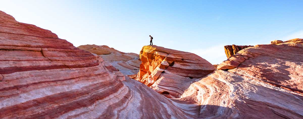
Fire Wave
One of the best places to get photos in the Valley of Fire State Park.

🥾 Easy | 1.5 miles round trip | Google Maps | Park Website | 1 Hour Drive from Las Vegas | Cost: $10 entrance per Nevada vehicle, $15 out of state vehicles
⚠️ Closure Note: The Fire Wave Trail is closed from June 1 through October.
Valley of Fire State Park is where you will find the Fire Wave Trailhead, and it is one of the most popular hiking trails in the park. This trail is directly in the desert sun, causing seasonal closures from June through September. Regardless, always start early and bring lots of water.
This out-and-back hike is perfect for beginner hikers because you just follow the markers and there are not too many areas where you must climb. Once you get to the end of Fire Wave, you will see the beautiful orange and red rocks which come together to look like a natural wave, hence the name. The scenery along this hike is stunning, so don’t forget your camera.
📚 Related Reading: Arrive to the trailhead prepared with our helpful Hiking Essentials Packing Checklist!
Historic Railroad Trail
Venture through old railroad tunnels while taking in magnificent views of Lake Mead.

🥾 Easy | 7.5 miles round trip | Google Maps | Park Website | 30-minute Drive from Las Vegas | Cost: free
The Historic Railroad Trail at Lake Mead takes you through an old, abandoned railroad track dating back to the 1930s. Along this popular trail, you will encounter different tunnels, each with different stories attached to them. There are also multiple signs along the trail to inform you about the history of different parts of the railroad, so you actually learn a lot.
This trail is more like a walking trail, which means it is perfect for everyone, and you can even bring your dogs. Another great part about exploring this historical trail is that you will see the gorgeous desert landscape and Lake Mead below.
At the very end of the trail, you will have the option to take an elevator down to the Hoover Dam Visitor Center and continue your adventure with a guided tour.
Calico Tanks
Catch breathtaking views of the Las Vegas Valley at the top of Calico Tanks in Red Rock Canyon National Conservation Area.

🥾 Moderate | 2.2 miles round trip | Google Maps | Park Website | 30-minute Drive from Las Vegas | Cost: $20 entrance per vehicle
Calico Tanks is one of the most popular Las Vegas hiking trails. You will see gorgeous red rocks, climb up the rock staircases, and take in the natural beauty surrounding you. On this hike, you will definitely need to use your hands and feet to maneuver over the rocks in certain areas.
Toward the end of the trail, you will come to red rocks which look almost like tanks, giving the trail its name. It is a beautiful trail to take photos or to escape from city life every once in a while.
✈️ Visiting Vegas? Check out my guide to where to stay in Vegas!
Gold Strike Canyon Hot Springs
Get lost in a wonderland of hot pools and waterfalls at Gold Strike Canyon Hot Springs near Lake Mead.

🥾 Difficult | 6 miles round trip | Google Maps | Park Website | 35-minute Drive from Las Vegas | Cost: $25 entrance per vehicle
Gold Strike Canyon Hot Springs is one of the most fun hikes in Las Vegas, but it is also on the more challenging side. You will encounter a set of eight different ropes which take you down through different boulders, and this is one of the trickier parts of the hike. The rocks along the path can also get pretty slippery, so be sure to wear adequate hiking shoes.
While hiking, you will see beautiful red rocks, captivating wildlife, and bighorn sheep are also very common on this path. Once you fully descend, you will find multiple hot springs and hot waterfalls around you. If you continue walking, you will end up at the Colorado River which is perfect for cooling off after a hot soak.
👉 Pro Tip: This trail is not available from May to September.
Frenchman Mountain
Get the best view of the sunrise in all of Las Vegas at Frenchman Mountain.

🥾 Difficult | 4.4 miles round trip | Google Maps | Park Website | 40-minute Drive from Las Vegas | Cost: free
Frenchman Mountain is one of the best hiking trails that lead you to magnificent views of the city. Some of the best times to take this hike are right before sunset or sunrise because the scenery you will get is unbelievable.
Lone Mountain Loop Trail
Take a hike in the middle of Las Vegas at Lone Mountain.

🥾 Easy | 3.2 miles round trip | Google Maps | Park Website | 15 minute Drive from Las Vegas | Cost: free
In Northern Las Vegas, you will find a mountain that is right next to the freeway and in the middle of a large residential area. This mountain is quite popular with the locals because it is a convenient yet gorgeous trail for when you want to indulge in outdoor activities.
The main trail of Lone Mountain is very easy and flat and takes you all the way around the mountain. However, you can choose to do some climbing on the other paths, which lead to unbeatable views of the Las Vegas Strip.
Bristlecone Trail
Cool off in the shady forest areas of Bristlecone Trail in the Spring Mountains.

🥾 Moderate | 6.3 miles round trip | Google Maps | Park Website | 50-minute Drive from Las Vegas | Cost: free
Many of the hikes in Las Vegas are beautiful, but they don’t offer too much greenery, trees, or shade. Bristlecone Trail, though, is one of the exceptions you will find on your Las Vegas hiking adventures.
Bristlecone Trail provides shaded forest areas, with enchanting views of the surrounding mountains. You may also spot many unique plants and wildlife during your hike, including the endangered Mount Charleston Blue Butterfly.
First Creek Canyon
Look out for hummingbirds and other alluring wildlife at First Creek in Red Rock Canyon.

🥾 Moderate | 4 miles | Google Maps | Park Website | 30-minute Drive from Las Vegas | Cost: $20 entrance fee per vehicle
Red Rock Canyon National Conservation Area contains many magnificent hikes, with First Creek Canyon being one of them. This is a popular trail for bird-watching, running, or just exploring.
The spring season is when you are the most likely to see the waterfall or water running through the creek. The trail starts flat and gets rockier as you continue on, but it is not too difficult to navigate over the rocks.
👉 Pro Tip: Snakes are a common sighting on this path, so be sure to keep an eye out.
Cathedral Rock
Hike through this colorful area with spectacular wildlife in Mount Charleston.
🥾 Moderate | 3 miles | Google Maps | Park Website | 45-minute Drive from Las Vegas | Cost: free
Cathedral Rock Trail in Mount Charleston is bursting with some of the best wildlife you will see on your Las Vegas hikes. Abundant, colorful wildflowers add to the scenery and draw a variety of butterflies.
The first half of the hike is steep, and it is important to wear good hiking shoes to make sure you stay safe. You may also see a waterfall on this hike, and the views of Kyle Canyon at the top are astonishing.
Note that the Cathedral Rock hiking trail is not open during winter.
White Domes Trail
Venture through a beautiful slot canyon featured in multiple movies at the Valley of Fire.

🥾 Easy | 1 mile | Google Maps | Park Website | 1 hour Drive from Las Vegas | Cost: $10 entrance per Nevada vehicle, $15 out-of-state vehicles
The White Domes Trail at the Valley of Fire State Park is an easy hike that takes you through a gorgeous slot canyon. You will be sure to see the expansive desert landscapes featuring incredible rock formations and wildlife. This hike is perfect for beginners and also those who love taking photographs.
Black Mountain Trail
Challenge yourself with this difficult hike to get the spectacular views in Sloan Canyon.
🥾 Difficult | 6.8 miles | Google Maps | Park Website | 35-minute Drive from Las Vegas | Cost: free
The challenging Black Mountain Trail at Sloan Canyon National Conservation Area is a very steep yet rewarding hike. There are a lot of switchbacks during this hike until you get closer to the top.
While this trail does not start out with a lot of scenery, it gets increasingly more beautiful as you continue on. There is not a lot of shade on this hike, so it is important to stay hydrated and hike during milder temperatures.
📚 Related Reading: Check out my day trips near Las Vegas article to find more things to do near Sloan Canyon.
Arizona Hot Springs
Soak in nature’s hot tub after a strenuous yet incredible hike near Lake Mead.

🥾 Difficult | 5 miles round trip | Google Maps | Park Website | 35-minute Drive from Las Vegas | Cost: $25 entrance per vehicle
Along the Colorado River, you will find the Arizona Hot Springs Trail. This hiking trail takes you through a bright slot canyon, and at the end, there are hot springs to take a rewarding soak.
There are four different pools in the canyon, and each of them has different temperatures so you can pick the one that is most comfortable for you.
The hike is long and strenuous. Be sure to get there early and bring a headlamp in case you need to navigate in the dark. If you want to extend your trip, you may also choose to camp near Arizona Hot Springs.
👉 Pro Tip: This trail is closed from May to September due to the extreme heat. Also, because of a recent flood, the ladder to reach these hot springs has been damaged and the attraction is currently inaccessible. Check the park website for updates.
***
Whether you’re visiting or living in nearby Las Vegas neighborhoods, I hope I inspired you to check out the best hikes near Las Vegas. Stay safe on the trails and enjoy!
Any suggestions for Red Rock Canyon activities?
A couple of hikes that weren’t’ mentioned. Big Falls is a 100 foot water falls. It starts out on the Mary Jane trails and branches off. This is specular. Above Big Falls is little known Hidden Falls. I just just up there in August and it was still running with a little snow. Also at Red Rock The Pine Creek trails have waterfalls rock climbers, this is world famous. The creek runs all year around and is under a canopy so it’s not too hot. The water flower from the top of Bridge Mountain, enjoy
Does Vegas have any hiking clubs? I’m traveling solo (for a conference) and prefer hiking with others.