The author's wife during a hike in St. John, USVI

15 Best Hikes on St. John, USVI (in 2023)

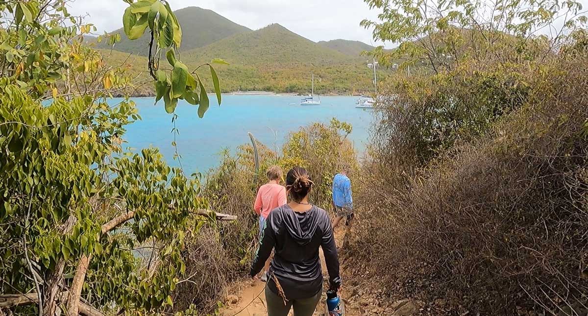
Out of all the Virgin Islands, St. John is by far the best for hiking. In large part, we can thank the efforts of the Virgin Islands National Park for all the great hikes in St. John. By protecting nearly 66% of St. John’s land area, the National Park Service has maintained some of the most beautiful hiking trails in all of the Caribbean.

And these trails are unique – mostly roadway remnants from centuries-old sugar mill plantations as they wind through the tropical forest. But the best part is most of the hiking trails in St. John gently slope into some of the most stunning beaches in the world.

My wife and I have made it our mission to trek them all. And I’d have to say, we’ve gotten pretty close. So here are my top picks for the best hikes on St. John. Enjoy!

Disclosure: Travel Lemming is an independent reader-supported blog. You can support us by purchasing via the affiliate links on this page, which may earn us commissions. See our Advertising Policy for further explanation. Thank you!

15 Best Hikes in St. John, USVI

Caneel Hill Trail

The more difficult of two hiking trails beginning in Cruz Bay.

Overlooking view of Caneel Bay during sunset
Sunset view from Caneel Hill overlooking Caneel Bay

🥾 Difficult | 2.4 miles one way | Google Maps | Trailhead directly in Cruz Bay just beyond Mongoose Junction

A mixed dry and moist forest ascends 720 feet to a scenic overlook of Cruz Bay atop Caneel Hill. Climb another 100 feet to Margaret Hill with an option to end your hike on Centerline Road. Otherwise, start your descent to the old Caneel Bay Resort to visit nearby Honeymoon Beach.

Be sure to allow enough time to explore Cruz Bay. It’s the largest town on St. John with many of our top things to do on the island.

Lind Point Trail

This trail begins in Cruz Bay before bringing you directly to a beautiful beach. 

View of boats on the blue water of Salomon Beach
Lind Point Trail ends at Salomon Beach

🥾 Moderate | 1.1 miles one way | Google Maps | Trailhead directly in Cruz Bay behind National Park Visitor Center

The trail ascends to a scenic overlook before wrapping around Lind Point, a dry scrub environment, and eventually descending to the white sands of Soloman Beach. It’s the best and easiest trail to do if you’re merely stepping off the ferry from staying on St. Thomas and don’t intend on using a taxi.

Peace Hill + Denis Bay Trail

Brisk walk to a grassy hill with an old sugar mill tower.

The Peace Hill Windmill during a hike in St. John
The Peace Hill Windmill is one of the easiest St. John hiking trails

🥾 Easy | .1 miles + .2 miles | Google Maps | 10 Minute Drive Time from Cruz Bay

Peace Hill features the first set of ruins you’ll find on the NorthShore Road after departing Cruz Bay. After a short walk, you’ll encounter the old windmill overlooking the glimmering waters of Hawksnest Bay. An optional side trail at the very beginning of your hike descends to the secluded shores of Denis Bay.

🗺️ Exploring Virgin Islands National Park: Peace Hill is just one of the many places of interest within the tropical park. For the others, check out our complete guide to Virgin Islands National Park.

Cinnamon Bay Self-Guided Trail

Meander through sugar mill ruins before a beach day at Cinnamon Bay.

The author in the ruins of Cinnamon Bay
The ruins of Cinnamon Bay are a fun way to explore the history of the US Virgin Islands

🥾 Easy | .5 miles | Google Maps | 15 Minute Drive Time from Cruz Bay

Utilize the Cinnamon Bay Campground parking area before taking a path that crosses NorthShore road for this self-guided tour. The easy trail twists through sugar mill remnants for a pleasantly shaded stroll that’s suitable for the entire family.

⛺Camping on St. John: Although camping opportunities are limited within Virgin Islands National Park, the Cinnamon Bay Campground is a great option. Read about it in our article, the best places to stay in St. John!

Cinnamon Bay Trail to America Hill

Rewarding view of the Northshore after a strenuous hike to America Hill.

Overlooking view of the turquoise blue water in Cinnamon Bay
View of Cinnamon Bay

🥾 Difficult | 1.1 miles one way | Google Maps | 15 Minute Drive Time from Cruz Bay

The trail starts beside the Cinnamon Bay Ruins before ascending through tropical forest to an old colonial estate, America Hill. You’ll be treated to breathtaking views of St. Thomas, Jost Van Dyke, and Tortola. Conversely, you can begin this trail on Centerline Road and descend to Cinnamon Bay’s NorthShore Road entrance.

Francis Bay Trail

One of a few hiking trails cutting directly through a mangrove forest. 

The author's wife walking the boardwalk in mangrove forest of Francis Bay
My wife walking the boardwalk through the mangrove forest of Francis Bay

🥾 Easy | .5 miles one way | Google Maps | 23 Minute Drive Time from Cruz Bay

An excellent choice for families to view a mangrove lagoon. The half-mile trail cuts through the tree roots of the important coastal trees before ascending to estate ruins from the old Annaberg Plantation. Stay and hang out at Francis Bay Beach afterward, one of the top beaches on St. John.

Leinster Bay Trail

A mostly flat hiking trail leading to Waterlemon Bay and the Murphy House.

View while on a hike in Leinster Bay Trail during a sunny morning
Don’t forget to bring a hat and sunscreen for this one!

🥾 Easy | .8 miles one way | Google Maps | 23 Minute Drive Time from Cruz Bay

After exploring Annaberg Plantation, one of the best places to visit in the US Virgin Islands, you’ll discover one of the easiest hiking trails in the Caribbean near the base of the former estate. The Leinster Bay trail runs parallel to sparkling blue water before ending at a walk-off point to Waterlemon Cay – a small islet with fantastic snorkeling.

Johnny Horn Trail

Connecting the Atlantic Ocean and the Caribbean Sea.

Scenic view of British Virgin Islands from Murphy House
Epic views of the British Virgin Islands are found at the Murphy House

🥾 Expert | 1.8 miles one way | Google Maps | 30 Minute Drive Time from Cruz Bay

Johnny Horn is the only continuous trail within Virgin Islands National Park connecting the Atlantic Ocean with the Caribbean Sea. Beginning in Coral Bay near the historic Emmaus Moravian Church, the trail climbs atop a steep ridge before slanting downward to Waterlemon Bay. Along the way, head up to the Murphy House or sidetrack to Brown Bay Trail.

Brown Bay Trail

An offshoot of the Johnny Horn Trail with a coral-covered beach.

View of the Tortola from Brown Bay Trail
Brown Bay Trail overlooks Tortola of the BVI’s

🥾 Expert | 1.6 miles one way | Google Maps | 30 Minute Drive Time from Cruz Bay

Within the Johnny Horn Trail is a sidetrack to the picturesque, coral-lined Brown Bay. The trail drops to a salt pond and sugar mill ruins before climbing one more ridge where you’ll be treated to stunning views of Hurricane Hole, a mangrove-lined lagoon just outside of Coral Bay. The trail culminates its descent on the East End Road, one mile east of Coral Bay.

Reef Bay Trail

Our top pick for hiking trails in St. John with its descent into island ecosystems and historical structures.

The author's wife posing for a photo in Reef Bay Sugar Mill Ruins
The Reef Bay Sugar Mill Ruins are among the most well preserved in the Virgin Islands

🥾 Difficult | 2.2 miles one way | Google Maps | 15 Minute Drive Time from Cruz Bay 

If you only have time for one hike in St. John, heavily consider hiking Reef Bay Trail. This trail has it all: old forest roads connecting centuries-old sugar mill ruins, tropical forests descending into dry scrub environments, mangrove ponds, ancient carvings, and a beautiful beach. You’ll need to set aside at least a half-day to fully enjoy everything the trail has to offer.

👉 Pro Tip: Slightly alternate the route of this hike even further by following the Lameshur Bay Trail halfway through. The trail connects Lameshur Bay, a secluded cove with plantation ruins, with Reef Bay adding another element to the already outstanding hike.

Petroglyph Trail

Ancient rock carvings from the Taino Tribe, the Caribbean’s first inhabitants.

A carvings on a rock in Petroglyph Trail
The mysterious carvings appear in what used to be a waterfall

🥾 Easy | .3 miles | Google Maps | Extension of Reef Bay Trail

A small sidetrack of the Reef Bay Trail is the Petroglyphs of Reef Bay. Carved by the Taino Tribe, the Caribbean’s indigenous people, the rock art likely signifies the tribe’s spiritual connection to the natural landscape. The trail extension is a short distance and an easy add-on for a day along Reef Bay Trail.

L’Esperance Trail

Half forested trail and half exposed-sun trail ascends from Reef Bay Beach.

View of the Reef Bay Beach from L’Esperance Trail
Striking views of Reef Bay

🥾 Difficult | 2.6 miles one way | Google Maps | 15 Minute Drive Time from Cruz Bay

Most people utilize this trail as an alternate ascent from Reef Bay Trail to complete a loop rather than an out and back. Along the trail, you’ll find plantation ruins, tropical forest roads, and switchbacks alternating between moist forest and dry scrub.

Bordeaux Mountain Trail

Excellent valley and ocean views along the old, shady Bordeaux Mountain Road.

Boats on the water of St. John and the Bordeaux Mountain
Bordeaux Mountain is the tallest point on St. John

🥾 Moderate | 1.2 miles one way | Google Maps | 22 Minute Drive Time from Cruz Bay

Bordeaux Mountain is the tallest peak on St. John and one of the more strenuous, yet rewarding, hikes on the island. The trail follows an old mountain road up forest valleys with sea views with a culmination near the mountain’s peak while featuring forest valleys. You’ll find the trailhead at the end of the dirt road beyond Little Lameshur Bay Road on the south side of Virgin Islands National Park.

Salt Pond Bay Beach Trail + Drunk Bay Trail

Easy stroll to beautiful Salt Pond Beach and beyond.

The author's wife passing by Drunk Bay
Salt Pond Bay Beach Trail leads to Drunk Bay before it ridges southward to Ram Head

🥾 Easy | .2 miles + .3 miles one way | Google Maps | 35 Minute Drive Time from Cruz Bay

The short Salt Pond Trail brings you to one of the best beaches in the Virgin Islands with some awesome snorkeling opportunities and plenty of sea turtles. For hikers, you can extend your hike into Drunk Bay Trail and Ram Head Trail.

Ram Head Trail

South end peninsula with panoramic views and a blue cobblestone beach.

The author's mom in Ram Head Trail
My mom climbing to Ram Head Point

🥾 Moderate | 1.0 mile one way | Google Maps | 35 Minute Drive Time from Cruz Bay

Ram Head is my personal favorite and the trail of choice when I have family in town. With that said, the trail is best done early in the morning when the temperatures are coolest. Park at the Salt Pond Bay trailhead and hike to the peninsula’s peak to witness the best panoramic view in the Virgin Islands.

Tips for Hiking in Virgin Islands National Park

View from Ram Head Point

🚗 Parking: Parking is free but limited to small gravel lots and street parking.

🎟️ Entrance Fees: The trails of St. John and Virgin Islands National Park do not require any entrance fees.

🏞️ Website Information: All hiking trails are within Virgin Islands National Park.

🏖️ Bring a Packable Beach Blanket: We use this lightweight, packable beach blanket from Grand Trunk on all of our hiking adventures.

🤿 Snorkel Gear: Most hiking trails on St. John lead to beaches and most beaches have fantastic snorkeling. Don’t forget to bring a handy travel set!

🌅 Hike early, Beach later: Many of the hikes in St. John lack tree cover so it’s always recommended to hike early as you can always cool off at one of the amazing beaches later.

🗺️ Bring a Map: Like this one from National Geographic!

FAQs About Hiking in St. John

Is there hiking in St. John?

St. John is the best US Virgin Island for hiking. In fact, St. John is in many respects the best place in the Caribbean to go hiking.

How long is Rams Head trail in St. John?

The Ram Head Trail on St. John is an out and back trail with a round trip distance of 2.0 miles or 3.2 kilometers.

🥾 Read Next: 7 Best Hiking Trails on St. Croix

* * *

Which of the St. John hiking trails are you most looking forward to? My two favorites are Reef Bay and Ram Head! Be sure to leave a comment below and let us know!


I hope I helped you find some fun hikes in St. John for your visit. Before you go, be sure to check out my complete guide to what to do in St. John

How useful was this post?

Click on a star to rate (you can leave feedback after clicking submit)

Help us help you travel better!

Your feedback really helps ...

What did you like about this post? Or how can we improve it to help you travel better?

Leave a Reply

All comments are moderated for compliance with our community guidelines. Most importantly be kind & be helpful!

Your email address will not be published. Required fields are marked *

This site uses Akismet to reduce spam. Learn how your comment data is processed.